

 FS Dreamscapes have been producing mesh for FSX for some time now. I purchased Utah and then California and Florida way back in the mists of time and as Dean Mountford the developer reminded me, I was his second customer. A terrain mesh should improve on the default FSX TM (which is pretty good in many areas) and ProMesh™ certainly does that. FS Dreamscapes have produced an accurate high definition terrain mesh for most of the USA states and many countries in Europe, with 28 titles being for sale at the time of this review. I look at 3 areas in the USA and Switzerland in Europe.
FS DREAMSCAPES – NEXTMAP® PROMESHâ„¢ — The Synchromesh Review
Background:
Briefly:Â In FSX we have basically landclass, terrain mesh and scenery (much simplified).
Landclass:
In simple terms landclass defines in FSX the landscape, ie hills, farmland, urban, town, city, rivers, deserts, forests, etc. For example FS Genesis landclass displays a particular texture in a grid of 1.2 km areas in FSX. Landclass interacts with terrain mesh, by loading the correct textures for a given landclass/ground area.
Terrain Mesh:
With the advent of FSX, ACES introduced a three dimensional mesh based on the curvature of the earth and finally displayed a “reasonably true horizon”. Again in simple terms, terrain mesh brings the terrain to life by displaying 3-dimensional topographical features, such as hills, mountains, valleys, rolling plains, ravines, gulches, etc. Usually good quality 3rd party terrain mesh adds detail and alters the elevation of these topographical objects making them look more realistic and better defined. In FSX terrain mesh is measured by its Level of Detail ie LOD and in the default FSX, the LOD for the USA is LOD 10 with a resolution of 38 metres and in Europe, LOD 9 ie a resolution of 76 metres. FS Dreamscapes claim that its ProMeshâ„¢ software for the USA is 8 times the resolution and 64 times more detailed than the default FSX terrain mesh. With respect to Switzerland, ie Europe, FS Dreamscapes claim their terrain is 16 times the resolution and 128 times more detailed than the default FSX terrain mesh for Europe. The ProMeshâ„¢ terrain mesh series is based on high-resolution NEXTMap® 3D elevation data for the USA and Europe produced by Intermap Technologies®. This comprises DEM (Digital Elevation Model / Map) and is available in two main types:
- DTM (Digital Terrain Model in 3-D):
Highly Accurate Elevation Data that shows what is underneath
the ‘bald earth‘ model:Â topographic models of the bare earth in which vegetation, buildings, and other cultural features are digitally removed to display the underlying terrain surface. Â
Resolution at 5 metres.
- DSM (Digital Surface Model):
The ‘canopy’ model.
A topographic model of the earth’s surface that includes elevations caused by buildings, vegetation, and roads, as well as natural terrain features.
DSM provides a geometrically correct base map
There are two versions of digital terrain models DTM v1.0 & DTM v1.5; DTM v1.0 is best for open areas that do not contain buildings; DTM v1.5 is better for urban areas and undergoes a more significant editing process that allows for a more accurate representation of the land. Both are used in ProMeshâ„¢.
So, in summary the NEXTMap® elevation data from Intermap Technologies® provide the ProMesh™ series with the following advantages:
- 5m NEXTMap®-based horizontal elevation spacing (accurate to 1-meter vertically)
- 128 times more detailed than the default terrain mesh in Flight Simulator X
- 64 times higher resolution than the default terrain mesh in Flight Simulator X
- 32-bit source data that translates into much higher vertical resolution in the dataset. 32-bit data compilation also reduces the striping and banding issues seen in other 16-bit rendered terrain mesh
- Fractional elevation sampling provides samplings to fractions of a meter vertically (e.g., 10.25m, 10.5m) compared to other mesh products with only whole number samplings (e.g., 10m, 11m), which means smoother terrain on the ground and even smoother landings
The NextMap® Mesh is much more accurate than the default SRTM used in FSX. Ideally a mesh add-on should enhance: Roads, Rivers, Streams, Bridges, Landclass, and Waterclass, and ProMesh™ delivers on most counts.
Installation:
These are extremely large files and you will need a fast Internet connection to download the files, but fortunately Simmarket® offers a CD-Service for large files such as these. (Accessed here: http://secure.simmarket.com/cd-service.phtml)
The NEXTMap ProMesh Europe files are installed by default into the main Microsoft Flight Simulator X/FS Dreamscapes folder.
To uninstall, run the uninstaller from the Start Menu under the FS Dreamscapes menu option. Alternatively, you can manually delete the files and uninstaller from the Microsoft Flight Simulator X/FS Dreamscapes folder and untick in the FSX settings.
The Manual
There are no manuals per se, but a document for each area that covers,
- Product Description;
- Features;
- Install;
- Software Limitations;
- Technical Support
The documents are installed in the Flight Simulator X/FS Dreamscapes folder.
If you want to see the Promeshâ„¢ over other terrain mesh products such as UTX series you need to ensure that the ProMeshâ„¢ mesh has a higher p
FSX Scenery Settings:
I used a texture resolution at 7cm, which will automatically sets the mesh resolution to 10m, so I changed that to 5 metres, and coupled with the new 196.45 drivers gives excellent texture clarity.
Other settings include:
|
FSX Scenery Setting |
Setting |
|
LOD radius |
Large |
|
Mesh Complexity |
75 |
|
Mesh Resolution |
5m |
|
Texture Resolution |
7cm |
|
Water Effects |
Low 2 x |
|
Land Detail Textures |
þ |
|
Scenery Complexity |
Extremely Dense |
|
Autogen Density |
Very Dense |
|
Ground Scenery Shadows |
¨ |
|
Special Effects Detail |
High |
These settings had little impact on smoothness in the SIM.
The Visual Experience
There is no doubt that ProMeshâ„¢ enhances the default FSX mesh, the mountains are more accurate, distinct, better shaped, and the use of accurate professional data is evident. I don’t intend to use many comparison screenshots between vanilla FSX and FSX + ProMeshâ„¢, but rather show images from the series so that simmers can make up their own minds about the quality of this software. Obviously ProMeshâ„¢ Switzerland will show more “improvements” than say Texas, due to the fact that Switzerland has a lot of mountains whereas Texas is relatively flat, ie the topography is much more diverse in Switzerland and the effects will be more dramatic. Universally not all of the changes are significantly better than the FSX default textures. Basically if the FSX textures are of a higher resolution than the standard default (78m), then the ProMeshâ„¢ series will not make as much of an impact as they do in some of the default 78m areas.
In summary the ProMesh™ products looked at here all produced significant improvements over the FSX default, textures (terrain), mountains, rivers, coastlines, etc. All the textures are so much more distinct, some of FSX textures seem to lack definition and the ProMesh™ series restore a clarity and realism. Looking at Google earth images you can see that the ProMesh™ series compare favourably with their real life equivalents. Sit back now and enjoy the screenshots
Switzerland: is a federal republic consisting of 26 cantons with BERN as the capital. Switzerland is located in central Europe and is bordered by Germany to the north, France to the west, Italy to the south, and Austria and Liechtenstein to the east. It comprises an area of area of 41,285 km2 (15,940 sq mi) and has a population of approximately 8 million. (Courtesy Wikipedia)
Switzerland comprises three basic topographical areas: the Swiss Alps to the south, the Central Plateau in the middle, and the Jura mountains to the north.
The mountains are big, with about 100 of Switzerland’s mountain peaks ≥4,000 metres. The most famous include: the Matterhorn (4,478 m/14,692 ft); the Jungfrau (4,158 m/13,642 ft) and the Eiger (3,970 m (13,025 ft.)
Switzerland has 14 major airports and may other smaller airfields and heliports, some of these are depicted below. Â (Courtesy Wikipedia).
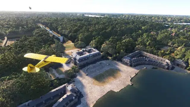
Interlaken is a well-known tourist destination in the Bernese Oberland, located between two lakes, and is 570 m (1,870 ft) above sea level. There is a military airfield, quite short which may not still be in use. The nearest mountain is the Jungfrau (4,158 m (13,642 ft)).
 Figure 2 FS Dreamscapes ProMesh Interlaken
 Figure 3 FS Dreamscapes ProMesh Switzerland in the Summer — Interlaken area
Zurich: this is the largest city in Switzerland. It is located in Eastern Switzerland at the northern tip of Lake Zürich. It has an international airport, 432m AMSL with 3 major runways, large jet capable. It is the cultural capital of Switzerland and is the gateway to the Swiss Alps. (courtesy Wikipedia)
 Figure 4 FS Dreamscapes ProMesh Zurich
 Figure 5 FS Dreamscapes ProMesh Approaching Zurich
BERN: This is the de facto capital of Switzerland, it is located in west central Switzerland it is close proximity to the Bernese Alps. The airport is 510m AMSL and has2 asphalt runways as well as one grass runway. (Courtesy Wikipedia)
 Figure 6 FS Dreamscapes ProMesh Approaching BERN
Basle (Basel): It is located in NW Switzerland, at the juncture of the Swiss, French and German borders. The international airport is operated jointly by two countries, France and Switzerland, and is sited entirely in France. The airport is 270m AMSL and has 3 major runways; it has three IATA airport codes: BSL (Basel) is the Swiss code, MLH (Mulhouse) is the French code, and EAP (EuroAirport) is the international code.  The ICAO airport code is LFSB. (Courtesy Wikipedia)
 Figure 7 FS Dreamscapes ProMeshâ„¢ Switzerland over BASEL
Lausanne: Lausanne is a city is situated on the shores of Lake Geneva, on the Swiss French Border. It is quite close to the Jura mountains. It has a small airport that can take up to light jets only, at an elevation of 495 AMSL.
 Figure 8 FS Dreamscapes ProMesh Switzerland over LAUSANNE
 Figure 9 FS Dreamscapes ProMesh Switzerland in the mountains near Saanen
Saanen: A ski tourist town, located in Eastern Switzerland in close proximity to the Swiss Alps. The airport is small and has an elevation of >1,000m AMSL>
 Figure 10 SAANEN Area Ravine
 Figure 11 FS Dreamscapes ProMesh Switzerland SAANEN area
 Figure 12 FS Dreamscapes ProMesh Switzerland SAANEN Google Earth
Matterhorn
The next two shots show how much accuracy is achieved with the ProMesh™ product. The first shot is a picture (Courtesy Wikipedia) of the Matterhorn and the second is a similar shot from FS Dreamscapes ProMesh™. This mountain is still undergoing development to make it even better.
 Figure 13 Matterhorn courtesy of Wikipedia
 Figure 14 FS Dreamscapes ProMesh Switzerland Matterhorn
Texas, USA
Galveston: is a coastal city located on Galveston Island in South Texas. It is approximately 45 miles (72 km) southeast of Houston. It has an international airport, with an elevation of 2m AMSL with 2 major runways.
Galveston with a Google Earth shot compared to FS Dreamscapes ProMeshâ„¢
 Figure 15Â Galveston from the Air courtesy Google Earth
 Figure 16 FS Dreamscapes ProMesh TEXAS Galveston from the air
 Figure 17 FS Dreamscapes ProMesh TEXAS Galveston close up from the air
Abilene Texas
Abilene is a city located west central Texas, being 240 km west of Fort Worth and 350 km North West of Austin. It has a regional airport with 3 runways at an elevation of 546 m AMSL (courtesy Wikipedia)
Another couple of comparison shots: First Google earth then FS dreamscapes.
 Figure 18 ABILENE courtesy Google Earth
 Figure 19 FS Dreamscapes ProMesh TEXAS ABILENE from the air.jpg
DALLAS
Dallas is the third-largest city in Texas and the eighth-largest in the United States; it is located in North Texas. It is a mostly flat area with an average elevation of approximately 140m AMSL. Dallas has 2 major two airports: Dallas/Fort Worth International Airport (2 x 7 runways) & Dallas Love Field (3 x 2 runways). There is also Dallas Executive Airport offering general aviation services for the city, and a number of airports around the city. (Courtesy Wikipedia).
 Figure 20 FS Dreamscapes ProMesh TEXAS DALLAS from the air
 Figure 21 Â FS Dreamscapes ProMesh TEXAS DALLAS 2 from the air
 Figure 22 Â FS Dreamscapes ProMesh TEXAS DALLAS 3 from the air
Amarillo, Texas Panhandle
Amarillo (“The Yellow Rose of Texas”) is the 15th-largest city in Texas, being the largest in the Texas Panhandle. The Texas Panhandle is a region of the Northern part of Texas, so called due its narrow pan handle like shape; it has mostly flat, grassy land or plains. (Courtesy Wikipedia). It has an international airport with 2 x 2 runways at an elevation of 1100 m AMSL.
 Figure 23 FS Dreamscapes ProMesh TEXAS PANHANDLE Amarillo
 Figure 24 FS Dreamscapes ProMesh TEXAS PANHANDLE 2 Amarillo
Laredo
Laredo is located on the north bank of the Rio Grande (RÃo Bravo) in South Texas, on the border with Mexico. Due to its location on the Rio Grande, it is the largest inland port in the USA. Topography: A few hills, flat lands, covered brush, grass lands, and trees, oak, and mesquite. Laredo has an International airport with 3 x 2 runways at an elevation of 150 m AMSL.
 Figure 25 FS Dreamscapes ProMesh TEXAS LAREDO
 Figure 26 Â FS Dreamscapes ProMesh TEXAS LAREDO 2 showing the Rio Grande
Miami Florida
Miami is the 7th largest city in the USA, and is positioned on the Atlantic coast in south-eastern Florida. It has an International airport, with 4 x 2 runways at an elevation of 2m AMSL. Other airports in the area include, Fort Lauderdale-Hollywood International Airport, Opa-Locka Airport, and Kendall-Tamiami Airport, all within easy reach of Miami.
 Figure 27 FS Dreamscapes ProMesh FLORIDA MIAMI 1
 Figure 28 FS Dreamscapes ProMesh FLORIDA MIAMI 2
 Figure 29 FS Dreamscapes ProMesh FLORIDA MIAMI 3
 Figure 30 FS Dreamscapes ProMesh FLORIDA MIAMI 4
 Figure 31 FS Dreamscapes ProMesh FLORIDA COAST 1
 Figure 32 Â FS Dreamscapes ProMesh FLORIDA COAST 2
The Everglades
The Everglades are subtropical wetlands located in the southern half of Florida. The Everglades National Park (3rd largest in the USA) covers 1,509,000 acres (6,110 km2), in southern Florida. The elevation ranges from 0 to 2.4 m, AMSL. There are numerous airports/airfields in the region.
 Figure 33 FS Dreamscapes ProMesh EVERGLADES
 Figure 34 Â FS Dreamscapes ProMesh EVERGLADES 2
Tampa
 Figure 35 FS Dreamscapes ProMesh TAMPA at altitude
 Figure 36 FS Dreamscapes ProMesh TAMPA area
San Francisco, Ca
 Figure 37 FS Dreamscapes ProMesh SAN FRANCISCO AREA 1 Half Moon Bay
 Figure 38 FS Dreamscapes ProMesh SAN FRANCISCO AREA 2
 Figure 39 FS Dreamscapes ProMesh SAN FRANCISCO AREA 3
 Figure 40 FS Dreamscapes ProMesh SAN FRANCISCO AREA 4
 Figure 41 FS Dreamscapes ProMesh SAN FRANCISCO AREA 5
Lake Tahoe
The Lake Tahoe area is a major tourist attraction in both California and Nevada. It is an alpine area hosting a number of ski resorts. The lake is 6,225 ft (1,897 m), AMSL, and it is situated on the border between California and Nevada. (Courtesy Wikipedia). There are a number of airports and airfields in the area.
 Figure 42 Â FS Dreamscapes ProMesh LAKE TAHOE AREA 1
 Figure 43 FS Dreamscapes ProMesh LAKE TAHOE AREA 2
 Figure 44 FS Dreamscapes ProMesh LAKE TAHOE AREA 3
Interaction of FS Dreamscapes NEXTMap® ProMesh™ with, FTX PNW, UTX, GexN, FSG LC and Mesh and future developments.
I spoke at length with Dean Mountford, the developer of the FS Dreamscapes ProMeshâ„¢ series, about how his products interact with (positively, negatively or neutrally) with the above series of 3rd party add-ons for FSX. I used all of these products in preparing the review, so it’s good to get an opinion from the developer on how they fit together. (Note FTX Pacific North West was not included in the review)
The following is Dean’s reply edited as necessary:
NEXTMap® ProMesh™ will be compatibility with FTX PNW (once Washington State is completed). We are planning on a 2m elevation enhancement data as a companion product to NEXTMap® ProMesh™ as well for the Seattle area.
UTX AK/USA/CANADA and EUROPE all only affect vector data but we highly recommend users purchase UTX as a companion product as it corrects the water bodies that were not well defined in the default FSX data. UTX provides highly accurate water bodies and removes the majority of water anomalies, and also the coastlines and roads are so accurate that the two product lines combined make a wonderful addition.  Allen Kriesman is also a friend of ours and we are in communication pretty regularly and have some things we’re talking about for the future.
GEXn is basically a texture replacement add-on for the ground and building textures in FSX and is completely compatible. In fact, the two products do different things, the NEXTMap® ProMesh™ data affects the shape of the terrain (i.e. mountains, hills, gullies), contrasting with GEXn which affects the textures that are overlaid on the terrain. Many of our users are using GEXn and love the combination of both products.
FS Genesis is also a good companion product to the NEXTMap® ProMeshâ„¢ data, especially for all areas outside of the USA and Europe. Most of the default FSX elevation data outside of these areas is 608m spacing between elevation points and Justin Tyme of FSG has rendered the whole world in 78m (based on SRTM 90m) elevation data. For all areas not in 5m Justin’s data is well worth getting. Justin is also a long time friend and we highly recommend his SRTM datasets for the rest of the world.
Development and the Future
The NextMap® ProMesh™ product line so far has been:
- Version 1.0 used the default FSX SDK data for x,y dimensions of each elevation point.
- Version 2.0 used custom x,y dimensions that FS Dreamscapes developed, and are much more accurate than the SDK figures, which in turn leads to better rendering and performance.
- Version 3.0 is planned which will fix all airport plateaus;
and all plateau fixes will be designed with photo scenery in mind
We are also planning a free 5m photo scenery upgrade for all NEXTMap ProMesh products covering the USA once we finalize the processes. .
Our products are all free lifetime upgrades, and customers who buy directly through our store can download updates as they become available. We’re also working on a line of 1m per pixel photo scenery products for the whole of the USA and we’re close to going live with that data soon.
I’ll continue to gather the information about the NEXTMap® data and how it is much improved from the USGS 10m data and the SRTM 90m data…
Dean Mountford Developer FS Dreamscapes NextMap ProMesh, April 2010
Summing Up
These are excellent scenery add-ons from FS dreamscapes.. They use extremely accurate data from a commercial source and have a policy of constantly improving their products. It is good to see that they complement other mesh, landclass, etc add-ons for FSX, ie FSG LC & Mesh, UTX, GEXn FTX, etc with the combination giving a much better look in the sim. Using Google Earth I can verify that the ProMesh textures represent the Earth’s terrain with a high degree of accuracy.   Support is excellent and the forum offers a lot of tips and tricks.
WOW Factor: 9 out of 10.
Peter Hayes, Australia, April 2010
|
Publisher / Developer: |
FS DREAMSCAPES |
|
Supplier: |
|
|
Download |
Texas                                      2.93GB; Switzerland                            581MB South California                     1.7GB California                               798MB |
|
Installed File Size: |
Texas                                      2.93GB; Switzerland                            630MB Florida                                    841MB |
|
Simulator Requirement: |
FSX (no specification for SP1, SP2 (Acceleration/Gold)) |
|
OS Requirements: |
Win XP, Vista and/or Win 7; |
|
Testing System: |
Intel E8600, 4GB DDR 800 RAM, Vista 64 SP2, nVidia 9800 GT, 182.50 Driver; |
|
Scenery: |
FSX Default; FS Genesis, UTX USA/Canada; GEXn; FEX, FTX. |
|
Installation: |
Installation is simplicity itself being automatic via a self extracting exe file. Should be installed with Admin rights — VISTA right click “Run as administrator”. |
|
Manuals / Documentation |
No real manual but a document file for each area detailing: Product Description; Features; Install; Software Limitations; Technical Support |
|
Uninstall |
Uninstaller included |
|
Support: |
http://www.fsdreamscapes.com/forums |
|
Homepage: |
http://www.fsdreamscapes.com/ |
Interesting You Tube videos on digital mapping:
- http://www.youtube.com/watch?v=jOccS8mUqI8
- http://www.youtube.com/watch?v=YNArJBJ–4U
- http://www.youtube.com/watch?v=EgRJhFsE6bo
- http://www.youtube.com/watch?v=kT50Z-AcGwg&feature=related
Appendix 1
Notes on Terrain Mesh in FSX provided by Dean Mountford FS Dreamscapes.
SRTM Data defined…
The data is from the Shuttle Radar Topography mission which dates back to 2000 and was a one pass deal.  If there were clouds over the earth large areas became voids in the data which require interpretation from software or filling in the data with other data sources, usually at a lower resolution. The Root Mean Square Error (RMSE) i.e. average vertical error on the SRTM data is a whopping 20-30m vertically. i.e. the elevation points could be up or down from its real world location by a matter of 10m, i.e. 30 ft. In default FSX a lot of mountain tops such as the Matterhorn are completely missing, and this is the case throughout most of the SRTM dataset.
Accuracy +/- 10m Absolute RMSE (The Root Mean Square Error)
USGS NED Data defined…
The data is derived from land surveys, lidar, IFSAR and various other mapping technologies, with some maps dating back to the 1960’s. The data was collected by many different agencies over several  years. Sometimes the data is in 16bit (which leads to stair stepping and tiger striping on the terrain) and other times it’s in 32 bit… The problem is the NED dataset suffers from quality control issues as you can’t have a continent wide dataset that is uniform when using so many technologies and agencies and acquisition formats… Also a lot of new highways are not represented in these datasets such as interstates that cut through mountains etc. It also is missing details such as quarries and open cut mines… (RMSE) i.e. average vertical error on the NED data is a substantial 3m vertically. i.e. the elevation points could be up or down from its real world location by a matter of 20-30m, i.e. 60-90 ft
Acccuracy +/- 2.44m Absolute RMSE
InterMap NEXTMap® data.defined..
The data is uniform across the United States and Europe, taken with the same sensor technology in a short time frame. The aircraft used was a Learjet 35 fitted with an IFSAR system and acquired between 2005 – 2008. This means all data is the same quality and also doesn’t suffer from the issues the SRTM missions had with clouds etc and while a few locations such as Monument Valley and Bryce Canyon may be difficult to map sharp cliffs and small vertical drops over 99.9% of the data is extremely accurate. For those areas that may be missing critical data (such as we had with Half Dome in California) all we need is for customers to give us feedback on what needs improving and we can pass it along to Intermap so the data for that area can be given special attention. We actively encourage customers to let us know where inaccuracies may exist so we can make the product even better.
Accuracy +/- 0.7 Absolute RMSE
Appendix II — InterMap Tecnologies
Further notes from InterMap:
- “Our core products are created according to tightly controlled specifications, resulting in consistent, seamless data that span entire land masses.
- These products vary only when the specifications are upgraded – to reflect improvements in our equipment, for example.
Digital Terrain Model (DTM)
Intermap has two versions of the DTM, based on when the data was collected and how it was processed. The differences between the two versions, DTM v1.0 and DTM v1.5, are described in Section 6.2, Product Characteristics. When the DTM is mentioned in this product handbook and no version is mentioned, the implication is that the data being referred to is DTM v1.5. If you have specific questions about Intermap’s DTM data and which DTM is best for your particular applications, please contact an Intermap sales representative.
- The DTM is a topographic model of the bare earth that can be manipulated using a computer. The DTM has had vegetation, buildings, and other cultural features digitally removed, leaving just the underlying terrain. This is achieved using our proprietary software, which derives terrain elevations based on measurements of bare ground contained in the original radar data as well as manually reviewing and editing every tile.
- The key feature of the DTM is that it infers the terrain characteristics that may be hidden in the DSM. Figure 2-4 illustrates that the buildings and trees evident in the previous figures are no longer visible. See Section 6.2, Product Characteristics, for a sample list of applications that can use the DTM v1.0 and DTM v1.5 data.
IFSAR Technology
Interferometric synthetic aperture radar (IFSAR) is a well-established remote sensing technology for obtaining high-resolution elevation data and corresponding ortho-rectified radar images of the earth’s surface from airborne and space borne platforms.
IFSAR remote sensing systems are capable of generating topographic data with accuracies measured in centimetres. These systems rely on electromagnetic energy of a specific wavelength to collect information about their targets or the terrain they image. Remote sensing systems are defined as being either active or passive, and the distinction is important. Passive energy is energy that is naturally available, such as energy from the sun, whereas active energy is energy that is generated by a human made source, such as a radar antenna. Aerial photography, for example, is generated by passive remote sensing systems that require the sun to illuminate the terrain they image. On the other hand, IFSAR systems are active systems that provide their own source of illumination, in the form of radar pulses, when imaging the terrain.
Understanding Accuracy
Various types of terrain features make areas unsuitable for validating accuracy. As a rule, areas with unobstructed terrain of moderate slope less than 10 degrees are suitable for validating accuracy, but areas with the following characteristics are unsuitable for validating our product accuracy.
- Urban areas: Areas including residential, commercial and industrial may appear to be open areas suitable for validating accuracy in the data, but the proximity of cultural features such as buildings, houses, cars, light standards, utility lines, as well as roads, bridges, and parking lots can reduce the absolute accuracy in the data. This is because these features can block or otherwise interfere with the returned radar signal. As such, these areas are not suitable for validating the accuracy of our data.
- Dense tree cover: Areas of dense tree cover, where the IFSAR technology does not penetrate the canopy well, prevents us from capturing ground elevation information. Consequently, these areas are not suitable for validating the accuracy of our data.
- Scrub brush and scattered trees: Areas of scattered trees or extensive scrub brush, where the spacing among them within our ORI appears to indicate sufficient open area, may still pose a problem as areas for validating accuracy. This is because the ORI has a 1.25 m resolution, whereas the DEM data has a 5 m resolution or cell size. Combined with the effects of the viewing geometry in these areas, these features can affect the accuracy of our DEM data enough that these areas are excluded as areas suitable for use in validating the accuracy of our data.
- Areas near water bodies: Because radar signals respond to water bodies in a similar manner to how they respond to parking lots, open areas that would otherwise be suitable locations for validating accuracy could be affected because of their proximity to water. Additionally, these areas are subject to the effects of temporal changes – changes in shoreline location – so we cannot expect consistency in the elevation readings in these areas. Consequently, these areas are not suitable for validating the accuracy of our data.
- Construction sites: Areas under construction should not be used as locations for validating accuracy. While at the time of the survey the land may be an open, low slope area, if there is any evidence that may change, then a more suitable location should be chosen to validate the accuracy of our data.
- High-slope areas: Areas of high slope, along with factors such as the magnitude of the slope, whether it is positive or negative, where it lies in the radar swath, and the aspect angle relative to the look angle, can cause reduced accuracy in elevation. As a result, areas with slope greater than 10 degrees are not suitable for validating the accuracy of our data.
- Side-viewing geometry: The radar views to the side of the aircraft with local incident angles of about 35 to 55 degrees. Therefore, in the direction perpendicular to the flight path, there are shadow effects behind tall structures and layover effects in front. For example, a 10-meter vertical structure could affect the terrain as far away from the structure as 17 meters. This has two consequences in urban areas:  These areas often contain voids, and interpolation is used to compensate for data loss. . In areas with narrow streets parallel to the flight line, the buildings may obscure the streets, so there may be no sampling of the bare earth in the street itself.
- Slope effects: Slopes greater than 10 degrees cause reduced accuracy. (Slope may be terrain slope or it may also be localized slopes caused by first surface features.)Â The impact depends on the magnitude of the slope, whether the slope is positive or negative, aspect angle and where it lies in the radar swath (look angle). As a general rule, the RMSE will increase in areas with slopes above 10 degrees. In areas with slopes of 20-30 degrees, the RMSE is estimated to double, and it will continue to increase as the slope increases.
- Rapid changes in terrain: Rapid changes in terrain from features such as ridgelines, treelines or drainage embankments can cause a similar increase in error.
- Additionally, the DTM interpolation process may generalize the terrain, creating local errors. Elevations in the DTM may not be completely preserved as in the DSM.  Utilizing break-lines during the interactive editing stage reduces these effects. These break-lines are only used during the editing process and are not maintained or deliverable with the final product. Similarly, the transition zone between obstructed and unobstructed areas (usually less than 25 meters) may have edge-effects.
DTM-related issues: The process for creating a bald-earth DTM (using proprietary software developed by InterMap) attempts to remove the first surface features in the DSM (e.g. buildings, utility features, trees and forest, etc). Obstructed areas, although processed and interactively edited to lessen the effects of first surface features, may not meet the same vertical accuracy as unobstructed areas with slopes less than 10 degrees. Consequently, these areas must be excluded from any validation testing.
Phase de-correlation effects: As the data is being gathered, a de-correlation of phase between the two antennae can occur. This is more common with radar systems that require two passes over a target area, but it can occur, to a lesser extent, with one-pass systems such as those used by Intermap. The result of phase de-correlation can be an unreliable measurement of height variation and a potential loss of data. That data loss is manifested as data dropout in the imagery and as areas requiring interpolation in the elevation data. Data processing techniques are implemented to mitigate these effects.
Third-party Verification
Eleven independent agencies have validated our data, including the University of Stuttgart, the Environment Agency of England & Wales, University College London, USGS, NGA, NASA, DARPA, U.S. Forest Service, U.S. Army Corps of Engineers TEC, and the University of Washington.”


0 Responses
Great review! However, a comparison with the default FSX terrain would have been even more useful as it would demonstrate the effect of this expansion. Keep the reviews coming!
Hi Flo, I’m actually working on comparison shots right now to show the difference between the default FSX terrain and the NEXTMap® Promeshâ„¢ terrain, and should have some photos up shortly for Switzerland, followed by other areas in coming days and weeks…
Flo
I did consider doing just that but then I felt that someone contemplating buying a Promesh area would be better comparing their own PC pictures with my pictures. Looks like Dean has done it for me!! Thanks for your comments, it’s nice to know that the reviews are being read. Next One Fly Tampa Vienna with PM Austria!!
Regards
PeterH
PM Austria and Vienna 2.0 are working together nicely. Just on the danube side of the airport there are steeper cliffs, the rest ist neglectible. Salzburg is nearly perfect, and most of the smaller airfields in Austria Professional X are as well.
Hi, I just wanted to share a little something I put together comparing the best available USGS free data to the NEXTMap® ProMesh™ data.
I posted a couple of comparisons in my blog…
http://fsdreamscapes.blogspot.com/2010/05/national-elevation-dataset-10m-data-vs.html
I would like to find same meshes for FS9.
¿Is there something similar for FS9?
FS2004 only supports up to 19m data for display AFAIK, I am hoping to port this data over to FS2004 but it involves a lot more work than FSX does due to the way FS2000/2/4 are designed.
please, i need a digital terrain model for the world, if any one know how to get in mrr format please hellllllllllp