

Lately, Argentina is known has been known for it’s soccer team and now unemployed coach. Argentina is also known for it’s aviation history built on it’s military strength. Some of you may remember the Falkland Islands war in 1982 where the Argentine Air Force took on the mighty British fleet. This review I’ll cover TropicalSim’s SAEZ add-on for FS2004 and FSX which was built during World War II.
SAEZ, Ministro Pistarini International Airport, is the largest airport in Argentina and acts as the hub between domestic and international flights in Buenos Aires. There are two active runways – 11/29 at 3,300m (10,827ft), and 17/35 at 3,105m (10,187ft). In 2009 almost 8 million passengers passed through the gates.
The airport is not located near any obstacles and it’s nearly at sea level (66ft — 20m) so there’s no concerns about dangerous approaches. The STAR’s are pretty easy. The SID’s seem to be avoiding Buenos Aires leading me to believe that noise is a concern as it is at most international airports near large cities.
There are many navaids at SAEZ. They have a VOR frequency of 116.50, runway 11 has an ILS frequency of 110.10, runway 35 is 108.70, plus runway 11 has an NDB with a frequency of 305, and runway 35’s NDB is 237. Runway 11 and 35 have NDB’s further out but one each is enough right?!
Onto the TropicalSim review…
Installation
TS’s version is installed with an executable file (one each for FS2004 and FSX) but you still have to install scenery manually in FS. There’s a very brief manual of 6 pages. It’s just simple instructions on how to install written in English and Portuguese and a little note for Windows 7 users with a link to additional installation instructions. A little bit of information on the airport would have been nice. Some charts would be nice, too. You’re on your own. Finding current charts for Argentina is difficult. If you use Simplates or nDac you’re ok.


What you get
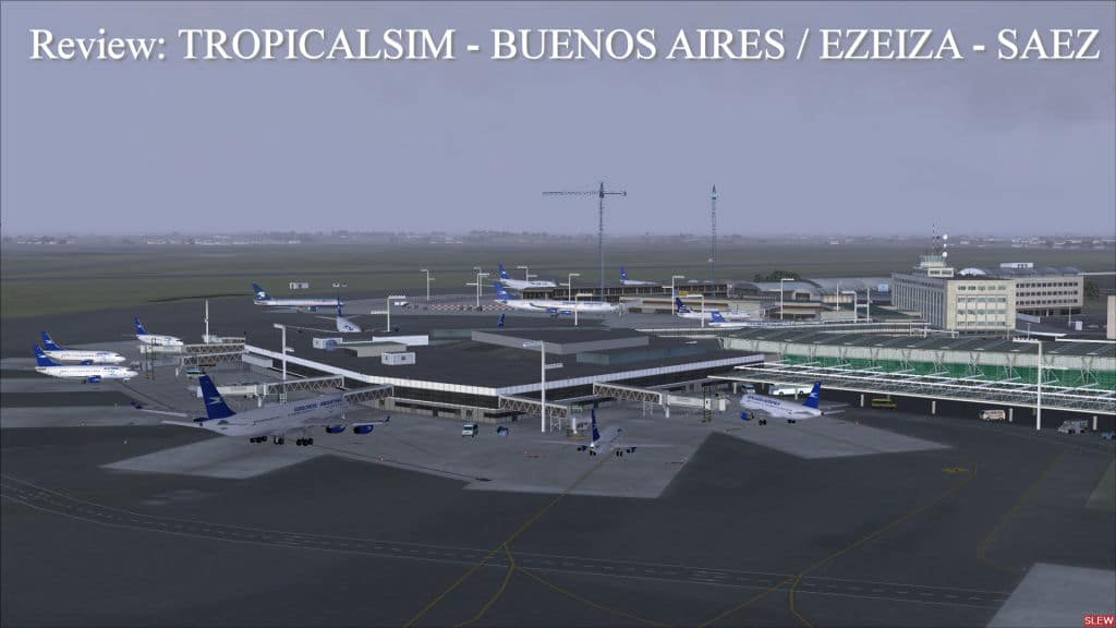
The entire airport is covered in detail. I’m really impressed with the number of buildings both airside and the parking side. Buildings are included for Aerolineas Argentinas and Aeropuertos Argentina 2000. Hangers on the north-east end are numerous and you can park inside them. The carpark and drive up areas are included if you want to use one of the virtual cars available for download on some sites. There’s even a section of the airport under construction that TS has included with the cranes and barriers. See the pictures below to confirm my statements. Also, you get a customized AI traffic file. An airport add-on with the AFCAD file is surely a must nowadays and TS has included one. Only problem is that the parking spots inside the hangers are labeled as gates so you may be sent to park there unexpectedly. It hasn’t happened to me yet because there’s plenty of parking available at the terminal and the hanger gates are labeled with high numbers. I think, but don’t quote me on it, that FS picks the low gate numbers first when assigning you to a gate at arrival.


Finally, you get photographic ground scenery for the airport which really adds to the look and feel of being there. The ground scenery has shadows so TS placed buildings where they exist to make it look more realistic. They do not change with the time so it will look the same throughout the day but that’s how all photo scenery works. There are some areas that look like shadows where TS has placed nothing and it does look a little odd. Looking at Google Earth it’s hard to tell if they are trees or little ponds so I can’t knock TS for this. When I compare the scenery to Google Earth I see a new terminal that isn’t represented in TS’s scenery. I assume it’s because it wasn’t built when TS was working on this scenery. Perhaps we can convince TS to release an update that includes the new terminal. The taxiways are accurate and building locations and shapes are nearly accurate. Again, the Google Earth image is more current than TS’s working images I assume.
See the images below. Notice the sharpness of the scenery and the see through tinted glass. Nice. Some more pics show the walkway to Terminal A and other locations. The ground roads around the terminals on the car side are using the photographic scenery which doesn’t look good in my opinion. Actual roads would make this look better as you can barely make out the roads using photo scenery. Signs in the parking areas are included and easy to read if you’re really into that much detail.


Another nice feature is that in FS 2004 they’ve included animated cars on the highways near the airport. This is a tricky feat in FS 2004 as moving cars are not supported as they are in FSX. Also note that the framerate hit in FSX is something best left for those with powerful systems. I lost 8 fps with scenery complexity at full. FS 2004 doesn’t seem to be hit as hard and I barely noticed a difference on my system (see specs below).
Is it worth it?
This is the hard part of the review. TropicalSim obviously put allot of time into their work and I don’t like to discourage further developments… but there’s competition for this airport. TS’s price is 17 Euros or about $27 Can/USA which includes FS 2004 and FSX versions. You can buy a competitors scenery which also includes SVMI – Caracas, Venezuela, for a total of $32 Can/USA or 24 Euros.
You won’t be disappointed with TS’s scenery. In my opinion they’ve done a better job of capturing the feel of the airport and the detail is much better.
Filesize: 27mb for FS9 and 48mb for FSX
Developer: TropicalSim
Price: 16.99 Euros without VAT or 20.22 with.
Buy and download it at Simmarket! There’s more pictures at Simmarket, too.
Andrew Barter’s test system:
Intel Core 2 Duo (e8400) overclocked to 3.3ghz, 4 gb 800 mhz RAM, Windows 7 64-Bit Home Premium, EVGA 512mb 9800GT video card, Samsung 2494HM 24″ widescreen at 1920×1080.
0 Responses
Hello Andrew,
Thanks for the review. We would like to point out something however:
“When I compare the scenery to Google Earth I see a new terminal that isn’t represented in TS’s scenery.”
This is actually the other way round. The building you see there on Google Earth no longer exists, it’s been torn down for the terminal expansion and there is nothing there now but rubble and construction work.
We actually represented the construction work on our scenery, as listed on the product features on the simmarket sales page.
Here are the images of that place being torn down in real life:
http://www.tropicalsim.com/adsc01105.jpg
http://www.tropicalsim.com/DSC00636.jpg
So we are in fact ahead of google earth :-).
As for the price comparison, we actually have the better deal as we make available BOTH FS9 and FSX for 17 euros, whilst the other version is 24 euros for FSX version and another 24 euros for FS9 version, totaling 48 euros, if you divide by the two airports, that’s 24 euros for Ezeiza FSX and FS9 but you won’t get it at that price so you’ll have to take Caracas as well and spend the whole 48 euros.
This is an example the kind of support you can expect from TropicalSim. They are on top of things! I apolgize about the Google Earth picture. I didn’t realize it was so old. TS is in fact more up to date! Way to go TS! I am a big fan of TS, btw. I have the Brazilian Majors, too, but I do try to be unbiased when reviewing.
About the price… the other developers SAEZ also includes SVMI at 12 euros for each version for a total of 24 euros, NOT 48 euros. So, if you only want SAEZ then it’s cheaper to go with TS. For an extra 4 euros you can get SVMI if you are interested.
Hello, i´m from argentina and i bought this scenery. I think that the textures are great and the reality of the airport is excelent, if you´ve been there you´ll see that it´s the same than reality, the only thing i want to say is that the people of tropicalsim forgot the ils of the runways, i think the are useful. that´s all, by!